-

by
Joe Lombardi
Weather
A Severe Thunderstorm Watch is now in effect for much of the region as scattered to numerous showers and storms are expanding.The watch does not currently include Long Island or New York City but covers much of downstate New York, as well as New England.The watch was issued at 1:05 p.m. Friday, Aug. 26, and will remain in effect until 8 p.m. Friday.A few storms may be strong or severe, ...
-
by
Michael Mashburn
Weather
Severe weather could be an issue around the region Thursday, July 28.The National Weather Service in Albany issued a severe thunderstorm watch that included much of the region, including Albany, Schenectady, Rensselaer, Dutchess, Ulster, and Sullivan counties.Forecasters said an approaching cold front will bring showers and thunderstorms to the region, mainly after 4 p.m. Some storms ...
-

by
Joe Lombardi
Weather
A Severe Thunderstorm Watch is now in effect for the region as rounds of storms are expected to roll through with damaging winds, quarter-size hail, frequent lightning, and isolated tornadoes possible.The watch went into effect Monday, July 25 at 1:05 p.m. and lasts until 8 p.m.Doppler radar and automated rain gauges indicated thunderstorms producing heavy rain across the area beginning ...
-

by
Joe Lombardi
Weather
A Severe Thunderstorm Watch is now in effect for much of the region, including parts of Long Island, as a new round of storms is expected to roll through with damaging winds and isolated tornadoes possible.The watch went into effect Thursday, July 21 at 1:15 p.m. and lasts until 8 p.m. It currently covers Nassau County, but has not been issued for Suffolk County.At 1:17 p.m., a severe ...
-
by
Joe Lombardi
Weather
A Severe Thunderstorm Warning is now in effect for much of the region as a new round of storms is expected to roll through with damaging winds and isolated tornadoes possible.The warning went into effect Thursday, July 21 at 1:30 p.m. and lasts until 2 p.m.At 1:28 p.m., a severe thunderstorm was located over Mount Kisco, moving northeast at 45 miles per hour, the National Weather ...
-
by
Joe Lombardi
Weather
A Severe Thunderstorm Watch is now in effect for all of Connecticut as a new round of storms is expected to roll through with damaging winds and isolated tornadoes possible.The watch went into effect Thursday, July 21 at 11:40 p.m. and lasts until 8 p.m.Some of the storms could produce gusty winds, the National Weather Service noted."Heavy downpours are likely in storms, which could ...
-
by
Joe Lombardi
Weather
A Severe Thunderstorm Watch is now in effect for much of the region as a potent system moves from west to east.The watch went into effect Tuesday, July 12 at 5 p.m. and lasts until 10 p.m.Hail up to 1-inch in diameter and wind gusts of between 60 and 70 miles per hour are possible, the National Weather Service said.Frequent lightning, thunder, and downpours will accompany strong ...
-

by
Joe Lombardi
Weather
A Severe Thunderstorm Watch is now in effect for much of the region as a potent system nears that will bring drenching rain, damaging wind gusts, hail, and frequent lightning.The watch went into effect Saturday, July 2 at 2:35 p.m. and lasts until 9 p.m.The main threat is damaging winds to 65 mph and hail to ping pong size, the National Weather Service said in a new update issued ...
-
by
Joe Lombardi
Weather
A Severe Thunderstorm Watch is now in effect as a potent system nears the region that will bring drenching rain, damaging wind gusts, hail, and frequent lightning.The watch went into effect Saturday, July 2 at 2:35 p.m. and lasts until 9 p.m.The main threat is damaging winds to 65 mph and hail to ping pong size, the National Weather Service said in a new update issued Saturday ...
-

by
David Cifarelli
Breaking News
Hold on to your hats! A wind advisory is in effect for the entire state of Maryland from 11 a.m. on Monday, March 7 to 1 a.m. on Tuesday, March 8.The National Weather Service (NWS) said the state could see wind gusts of up to 50 miles per hour over the next day. High winds are possible today as showers or thunderstorms move through the area. For the latest: https://t.co/Kt74D8dUsR #DCwx ...
-
by
Joe Lombardi
Weather
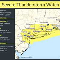
A quick-moving line of thunderstorms with strong gusty winds moving from west to east has resulted in numerous power outages on Long Island.As of around 4:15 p.m. Saturday, Nov. 13, PSEG Long Island is reporting 7,139 customers without power.Storm radar shows most of the severe storms have moved east, but a Severe Thunderstorm Watch remains in effect for all of Long Island until 7 p.m. ...
-
by
Daily Voice
Weather
A quick-moving line of thunderstorms with strong gusty winds moving from west to east has resulted in numerous power outages in the Hudson Valley.As of around 4 p.m. Saturday, Nov. 13, Con Edison is reporting 973 customers without power in Westchester while NYSEG says around 1,730 customers are in the dark in Northern Westchester.The estimated restoration time is 6 p.m. Saturday.Central ...


