Super Scorcher: Hottest Day Of The Year With Real-Feel Temps Climbing Near 110 Degrees Super Scorcher: Hottest Day Of The Year With Real-Feel Temps Climbing Near 110 Degrees Super Scorcher: Hottest Day Of The Year With Real-Feel Temps Climbing Near 110 Degrees
Super Scorcher: Hottest Day Of The Year With Real-Feel Temps Climbing Near 110 Degrees The hottest day of the summer has arrived. Friday, July 28 is expected to be a super scorcher, as temperatures are expected to be the highest they've been all summer, forecasters say. Temps are expected to peak above the 90-degree mark for the third day in a row in several major cities along the East Coast. Temps are expected to peak above the 90-degree mark for the third day in a row in several major cities along the East Coast.AccuWeather Good evening, severe weather threat has ended with the main story for Friday being the extreme heat! Posted by US National Weather Service Phil…
Super Scorcher Will Be Followed By New Round Of Severe Storms, Change In Weather Pattern Super Scorcher Will Be Followed By New Round Of Severe Storms, Change In Weather Pattern Super Scorcher Will Be Followed By New Round Of Severe Storms, Change In Weather Pattern
Super Scorcher Will Be Followed By New Round Of Severe Storms, Change In Weather Pattern The hottest days of the summer will linger into the first half of the weekend before an approaching cold front ignites a new round of severe storms that will lead to a big change in the weather pattern. Friday, July 28 is likely to be the warmest day of the week -- and perhaps of the year -- with the high temperature in the mid-90s, and a heat index (the combination of the temperature and humidity) around 100 degrees or more, according to the National Weather Service. In some parts of the Northeast, the heat index could hit as high as 110 degrees. (Click on the first image ab…
Strong Storms Could Bring Damaging Winds, Hail, Isolated Tornadoes Amid Hottest Air Of Summer Strong Storms Could Bring Damaging Winds, Hail, Isolated Tornadoes Amid Hottest Air Of Summer Strong Storms Could Bring Damaging Winds, Hail, Isolated Tornadoes Amid Hottest Air Of Summer
Strong Storms Could Bring Damaging Winds, Hail, Isolated Tornadoes Amid Hottest Air Of Summer As the hottest air mass of the season builds, a new round of scattered strong to severe storms will sweep through across the region. Strong thunderstorms will develop around midday Thursday, July 27, and track east during the afternoon and evening, the National Weather Service said.  Some storms could be severe with downpours, large hail, and damaging winds. A brief tornado is also possible, the weather service said in a Hazardous Weather Outlook statement issued early Thursday morning. Areas in orange in the first image above from AccuWeather.com have the highest …
New North Salem Resident Richard Gere Spotted At Popular Diner In Northeast New North Salem Resident Richard Gere Spotted At Popular Diner In Northeast New North Salem Resident Richard Gere Spotted At Popular Diner In Northeast
New North Salem Resident Richard Gere Spotted At Popular Diner In Northeast Actor Richard Gere, who resides in Northern Westchester County, made a cameo appearance at a diner in Northeast for an early morning bite on Monday, July 24, according to management.  "Look who stopped by for breakfast today," the restaurant at Sharon's Place in Scranton, Pennsylvania wrote in a Facebook post.  Look who stopped by for breakfast today!!😊😊 Posted by Sharon's Place on Monday, July 24, 2023 "Obviously, he knows who has the best breakfast in town!" wrote one restaurant-goer in the comments. "That’s amazing." Earlier report: Richard Gere Moves From One Northern Westchester…
Fall Forecast For Northeast Released By AccuWeather Fall Forecast For Northeast Released By AccuWeather Fall Forecast For Northeast Released By AccuWeather
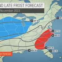
Fall Forecast For Northeast Released By AccuWeather AccuWeather has released its predictions for Fall 2023. Longtime meteorologist Paul Pastelok and his team of long-range forecasters say that this year's autumn, which officially kicks off Saturday, Sept. 23, will be coming in hot. The first few weeks of September will be around 90 degrees in New York City and Philadelphia, with cooler air expected to hit toward the end of the month, according to Pastelok. With it? Thunderstorms, he said. Severe Weather Risk September to November 2023.AccuWeather Fall's first frost is anticipated to make its debut at the end of October or early Novembe…
Fall Forecast For Northeast Released By AccuWeather Fall Forecast For Northeast Released By AccuWeather Fall Forecast For Northeast Released By AccuWeather
Fall Forecast For Northeast Released By AccuWeather AccuWeather has released its predictions for Fall 2023. Longtime meteorologist Paul Pastelok and his team of long-range forecasters say that this year's autumn, which officially kicks off Saturday, Sept. 23, will be coming in hot. The first few weeks of September will be around 90 degrees in New York City and Philadelphia, with cooler air expected to hit toward the end of the month, according to Pastelok. With it? Thunderstorms, he said. Severe Weather RiskAccuWeather Fall's first frost is anticipated to make its debut at the end of October or early November in the Northeast, Pastelok…
Line Of Severe Storms With Drenching Downpours, Damaging Wind Gusts Sweeping Through Region Line Of Severe Storms With Drenching Downpours, Damaging Wind Gusts Sweeping Through Region Line Of Severe Storms With Drenching Downpours, Damaging Wind Gusts Sweeping Through Region
Line Of Severe Storms With Drenching Downpours, Damaging Wind Gusts Sweeping Through Region As a cold front advances toward the Northeast, storm activity has developed, with some of the storms that are moving from west to east severe. A radar image of the region at about 1 p.m. Tuesday, July 18 above shows the severe storms (marked in red), which are packed with heavy rain, damaging wind gusts, thunder, and lightning. There is also an isolated threat for flash flooding, the National Weather Service said. Scattered storm activity is expected to continue until late Tuesday night. The outlook for Wednesday, July 19 calls for partly sunny skies and a high temperature …
Here's Projected Timing For New Round Of Storms With Damaging Wind Gusts, Risk For Flooding Here's Projected Timing For New Round Of Storms With Damaging Wind Gusts, Risk For Flooding Here's Projected Timing For New Round Of Storms With Damaging Wind Gusts, Risk For Flooding
Here's Projected Timing For New Round Of Storms With Damaging Wind Gusts, Risk For Flooding New update: Line Of Severe Storms With Drenching Downpours, Damaging Wind Gusts Sweeping Through Region A cold front advancing from the Great Lakes will move through the Northeast on Tuesday, July 18, igniting isolated thunderstorms, some of which could be severe. The projected timing for storms has shifted, with activity now expected from west to east starting in the early afternoon on Tuesday, July 18. The storms could produce heavy downpours and gusty winds.  "Scattered thunderstorms are expected to develop this afternoon with heavy rain possible, bringing an isolated th…
Tornado Watch Issued For Connecticut, With 60 MPH Wind Gusts, Hail Also Possible Tornado Watch Issued For Connecticut, With 60 MPH Wind Gusts, Hail Also Possible Tornado Watch Issued For Connecticut, With 60 MPH Wind Gusts, Hail Also Possible
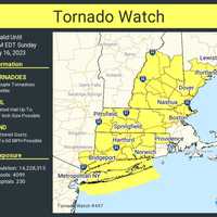
Tornado Watch Issued For Connecticut, With 60 MPH Wind Gusts, Hail Also Possible As a slow-moving storm system barrels through the Northeast, a Tornado Watch has now been issued for much of the region until 3 p.m. Sunday, July 16. It includes parts of southeastern New York -- Long Island, as well as Westchester, and Putnam counties -- as well as all eight counties in Connecticut, and the following counties in Massachusetts: Berkshire, Essex, Franklin, Hampden, Hampshire, Middlesex, and Worcester. A look at all areas under the watch, also including parts of Rhode Island, New Hampshire, and Maine, is marked in yellow in the image above from the National Weather Service. …
Flood Threat: Here Are Rainfall Projections For Storm System With Drenching Downpours Flood Threat: Here Are Rainfall Projections For Storm System With Drenching Downpours Flood Threat: Here Are Rainfall Projections For Storm System With Drenching Downpours
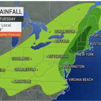
Flood Threat: Here Are Rainfall Projections For Storm System With Drenching Downpours New update: Tornado Watch Issued For Much Of Region, With 60 MPH Wind Gusts, Hail Also Possible With much of the region at risk for flash flooding, projected rainfall projections have been released for a slow-moving storm system that has arrived in the Northeast. The system is producing periods of heavy rainfall Sunday, July 16 as it moves from the west to the east. Parts of the region have already seen 1 to 2 inches of rainfall early Sunday morning. Up to 4 to 8 inches of rainfall are expected in areas shown in dark green in the first image above from AccuWeather.com. Flash fl…
Severe Flood Threat: Intense Downpours Forecast This Weekend Across Northeast Severe Flood Threat: Intense Downpours Forecast This Weekend Across Northeast Severe Flood Threat: Intense Downpours Forecast This Weekend Across Northeast
Severe Flood Threat: Intense Downpours Forecast This Weekend Across Northeast The Northeast is in store for another rainy weekend, this time with a possibility of flooding. According to AccuWeather meteorologists and the National Weather Service, severe downpours are posing a threat to the region. Strong to severe storms were expected across the region Friday, afternoon, July 14, and continue over the course of the weekend, the National Weather Service says. Showers and t-storms, a few of which could be severe, are likely mainly during the afternoon & evening hours the next... Posted by US National Weather Service Baltimore/Washington on Friday, July 14, 20…
New Rounds Of Storms With Downpours, Flash Flood Risk Threaten Region New Rounds Of Storms With Downpours, Flash Flood Risk Threaten Region New Rounds Of Storms With Downpours, Flash Flood Risk Threaten Region
New Rounds Of Storms With Downpours, Flash Flood Risk Threaten Region New rounds of storms with localized downpours and risks of flash flooding are taking aim at the region. The time frame for the first system is Thursday night, July 13 into Friday, July 14 with the approach of a frontal system, according to the National Weather Service. Rainfall of about 1 inch with locally higher amounts of around 2 inches is possible. "The strongest thunderstorms during this time may also be capable of producing damaging wind gusts," according to the weather service. The stormy pattern is expected to linger through Tuesday, July 18. "While a setup ex…